Chat with us, powered by LiveChat
NewDrillerDB Enterprise SalesSee it
Site Planning

Plan the well site in 3D before the rig rolls

Turn a project address into an interactive 3D model of the property - real terrain, aerial imagery, parcel lines, buildings, and nearby well logs. Stake the well, check setbacks and rig clearance, and hand the crew a plan they can hold.
1 click
from project to 3D site
3-page
proposal-ready PDF
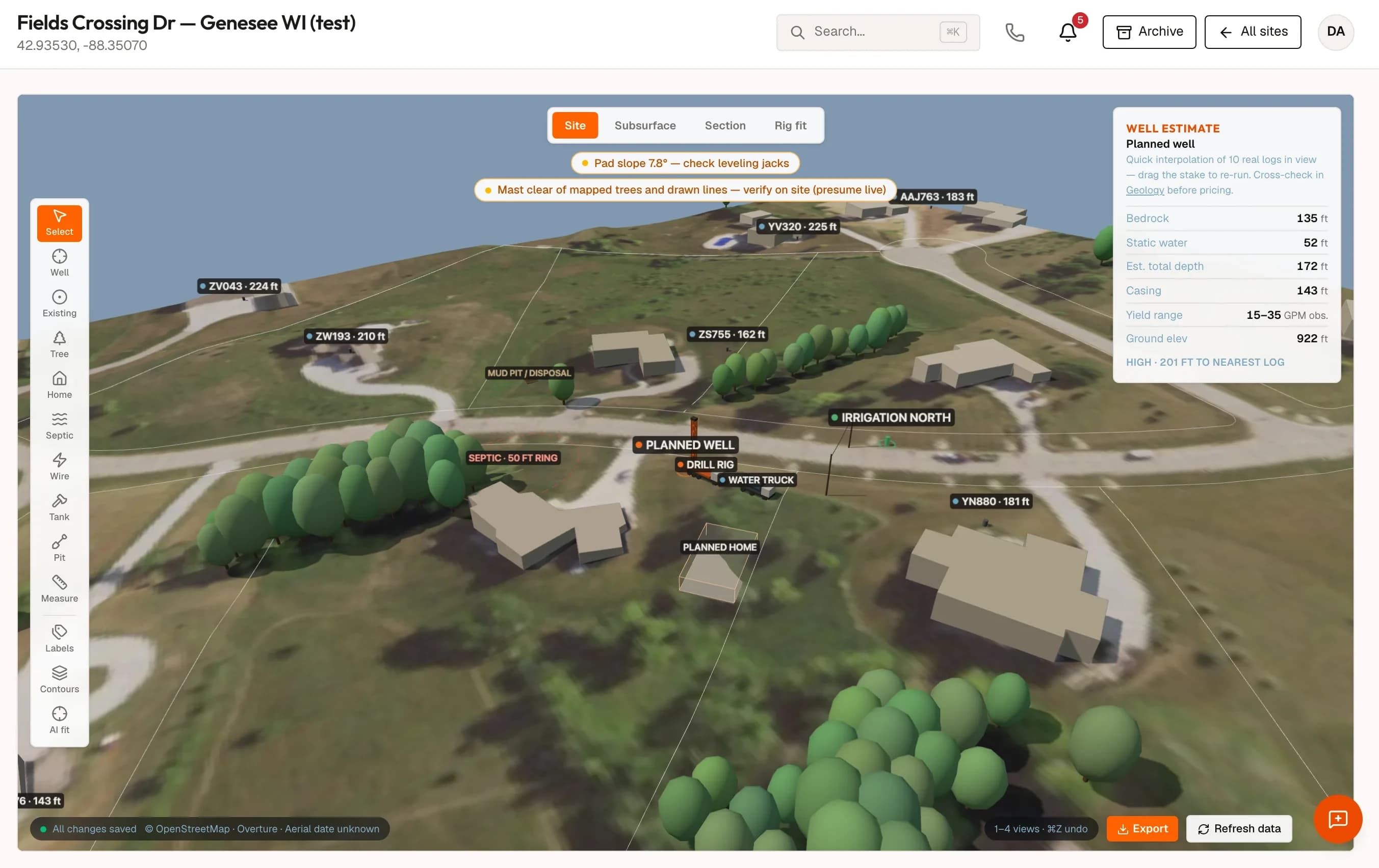
DrillerDB 3D Site Planner - staked well, drill rig, and septic setback ring on real terrain with a live depth estimate

The site walk, before you drive out

One click on a project builds the property in 3D from public data: USGS terrain, aerial imagery, parcel boundaries, building footprints, and the state well logs around it. Stake the planned well, drop the septic and its isolation ring, string the power line - and watch the clearance checks run live.

  • 1
    Real data, not a sketch

    Terrain elevation, aerial imagery, parcel lines, buildings, and nearby state well logs load automatically from the project address or GPS.

  • 2
    Setbacks and clearances checked live

    Septic isolation rings, well-to-well spacing, mast height against trees and drawn power lines - warnings update as you drag.

  • 3
    Depth estimates traced to real logs

    Bedrock, static water, total depth, and observed yield interpolated from the actual well logs in view - always with a confidence level and the distance to the nearest log. No nearby data means no invented numbers.

Teams use the site planner to:

  • Quote with a depth estimate backed by the logs next door
  • Catch setback problems in the office instead of on site
  • Show homeowners exactly where the well, rig, and lines will go
  • Hand the crew a stake table with GPS coordinates for every object
Key Capabilities

What the planner covers

A full site workflow in four views - Site, Subsurface, Section, and Rig fit.

Stake everything that matters

Planned and existing wells, trees, buildings, septic systems with editable isolation rings, overhead power lines, tanks, and mud pits - each with GPS coordinates you can copy.

See underground

Subsurface view renders nearby well logs as 3D lithology columns; Section view slices the earth at your well so you can drag casing and total depth against the formations.

Fit the rig

A pad-scoring heatmap blocks out buildings, septic, wires, and steep slopes. Drag the rig or let AI fit place it, with slope and mast clearance readouts.

Per-well drilling plans

Multiple planned wells each carry their own planned casing and total depth - tap a well on the section to re-cut the earth there.

Proposal-ready export

A branded 3-page PDF: north-up site plan, section side view with the drilling plan, and a stake table with coordinates, offsets, and bearings. Attach it straight to the project.

Shared per property

One site per property, linked to every job there - the pump crew opens the same plan the drilling project made.

Use Cases

Where the planner earns its keep

From the first quote to the day the rig arrives.

1

Quoting a new lot

Build the site from the address, read the depth estimate against the neighboring logs, and price the job with data instead of a guess.

2

New construction with a septic plan

Stake the septic and its isolation ring first, then find where the well can legally and physically go - before anyone commits to a spot.

3

Homeowner walkthroughs

Spin the 3D model in the meeting and drop the exported plan in the proposal - customers see exactly what they are buying.

Walk the site without leaving the office

Open any project, click Plan site in 3D, and see the property the way the rig will.